แสดงบทความที่มีป้ายกำกับ travel in thailand แสดงบทความทั้งหมด

Attraction:suratthani


History of Ko Samui

According to the evidence found on Samui Island, historians believe that it was first inhabited by man at most 1,200 years ago. In 1940s, the island was still isolated from the outside world. Those wishing to travel to Samui had to travel from Surat Thani for approximately 6 hours. As in-land transportation was not well established, it took several hours for people to walk through the lush jungles to the beach. It was only in the early 1970’s that Ko Samui became a dream destination discovered by backpackers.

With the development of infrastructure, an increasing number of travelers were attracted to the island. Samui’s concrete ring road was finished in 1973 by the order of the government. Passing beautiful beaches around the island and connecting sub-district areas, the road facilitated tourism. The Tourism Authority of Thailand explored the island in 1980 and realizing the high tourism potential of Samui, a plan to develop and promote tourism on the island was implemented. As a result, it has become and will continue to be a popular tourist destination in Thailand.


Today’s Ko Samui

Ko Samui is located in the Gulf of Thailand, approximately 84 kilometers east of Surat Thani Province, or approximately 700 kilometers south of Bangkok. Known as the Coconut Island, Ko Samui is one of the most famous and popular attractions of Thailand. With an area of 247 square kilometers, Ko Samui is the third largest island of Thailand after Phuket and Ko Chang (of Trat Province). The topography of the island is that of a plain with a mountain range in the middle and 7 important streams. In addition, there is a 50-kilometer paved road that encircles the island. Moreover, the area of the island stretches to a group of 48 surrounding islets.

Despite the fast pace of development, Ko Samui has been able to maintain its charm its classical image of a tropical beach resort fringed by coconut trees. Travelers to the island can enjoy a mixed blessing of vibrant day and nightlife along side with tranquility which can easily be found across different parts of Ko Samui as the archipelago is a peaceful home for fishermen and a natural den for seagulls and other rare birds.

Hat Chaweng and Hat Lamai are Ko Samuis most beautiful and most popular beaches. Both have a huge selection of accommodations suitable for every budget. Please note that room rates increase during the high season, from December to July, when Samui sparkles. The nightlife of each beach is different: Hat Chaweng is better for couples, women and families, while single men are drawn to the beer bar culture of Hat Lamai. These resorts, as well as Na Thon (Samui’s main town), have communications, exchange and car/motorcycle hire facilities. Other beaches include Hat Choeng Mon, Hat Mae Nam in the north and Hat Na Thon, the island’s major seafront settlement where shops, restaurants and tour agencies are concentrated.

Apart from its many lovely beaches and tranquil bays, Ko Samui is also noted for its high quality coconuts that grow densely everywhere. The best time to visit Ko Samui is from February to April when the sea is calm. The Southern dialect and the standard Thai language are spoken while English is widely understood in tourist areas.

Getting to Ko Samui

By air
Bangkok Airways flies from Bangkok to Ko Samui 13 times daily. The flight takes about one hour and 10 minutes. It also offers daily flights between Phuket and Samui. For more information, call its Bangkok office, 0 2229 3456, 0 2229 3434, Samui office, 0 7742 2512 - 9 or Samui Airport Office 0 7724 5601-8.

By bus
Air-conditioned and non air-conditioned buses leave Bangkok’s Southern Bus Terminal for Surat Thani several times daily. The trip takes about 11 hours. For further information, call 0 2435 1199, 0 2435 1200 (air-con), 0 2434 5557 - 8 (non-air-con).

By car
From Bangkok, take Highway 4 (Buddha Monthon Road) through Phetchaburi and Chumphon Provinces and then drive on to Highways 41 and 401 to Surat Thani Province. From Surat Thani, visitors can take their cars to Ko Samui through a vehicle ferry at Donsak Pier. The trip takes 1.30 hours.

By railSeveral trains leave Bangkok’s Hualamphong Station for Surat Thani daily. The trip takes about 12 hours. Train / bus / ferry combination tickets are also available. For more information, call Hualamphong Railway Station, 0 2223 7010, 0 2223 7020.

From Surat Thani to Ko Samui

1.Express boat

1.1 An express ferry boat of Songserm Travel departs from Tha Thong Pier in Surat Thani at 8.00 a.m. and arrives at Na Thon Pier in Samui at 10.30 a.m. every day. For the return trip, the boat leaves Na Thon Pier at 2.00 p.m. and reaches Tha Thong at 4.30 p.m.

1.2 Express boats of Seatran Express operate three times a day between Ban Don and Ko Samui. Departure times are 7.00 a.m., 12.30 p.m. and 2.30 p.m. The trip takes two hours.

2. Ferry Boats of Seatran

Seatran Ferry, which can accommodate 60 cars and 400 passengers, operates several trips per day between Don Sak (Surat Thani) and Ko Samui, from 5.00 a.m. to 5.00 p.m. The trip takes about 1.30 hours.

3. Night ferry

A slow night ferry leaves Ban Don Pier nightly at 11 p.m. and reaches Na Thon Pier at Samui around 5 a.m. (6 hours). For the return trip, the boat leaves Na Thon Pier at 9.00 p.m. and arrives at Ban Don Pier at 4.00 a.m. (7 hours).


Getting around Ko Samui

Samui is an explorer’s dream to discover something new. Offering a wealth of diversity of landscape, vistas, flora and fauna, and yet small enough to seek adventure in its many out-of-the-way places, Samui is best seen by taking songthaews (red local bus) which operate around the island. The fare starts at 20 baht, depending on the distance of the destination.

By Taxi
Taxi Meters are available for getting around Ko Samui. The taxi fare is shown on the meter with a surcharge of 90 Baht to the driver. Note: if you have any problem with taxi services on Ko Samui, please report to Public Bus Passenger Protection Center, Suratthani Provincial land Transportation Office, Ko Samui branch. or Call 1584


By a rented Jeep
Rented Jeep, 4WD, is available from many family-owned agencies and some well known large companies. The vehicle will serve as the basic means of transportation taking visitors around many hillside natural and man-made attractions which are easily accessible from the ring road. Some of these vehicles come with insurance, but the coverage is limited. Always ask for details first. The minimum price is from 800 baht.

By Motorcycle
A more flexible way to get around the island, rented motorcycle costs approximately 200 baht / day. Beware, as roads other than the main roads on Ko Samui are quite rough in some parts.


Getting to nearby Islands from Samui

1. Ko Pha-ngan

1.1 Na Thon Pier (Ko Samui) -- Thong Sala Pier (Ko Pha-ngan)

Songserm Travel Co. operates ferry boats and express boats between Na Thon Pier on Ko Samui and Thong Sala Pier on Ko Pha-ngan, four times a day. The trip takes about 45 minutes for express boats, and one hour for ordinary ferry boats.

1.2 Bo Phut (Ko Samui) -- Hat Rin (Ko Pha-ngan)

There is a ferry boat leaving Bo Phut for Ko Pha-ngan twice daily at 9.30 a.m. and 2.30 p.m. The return trips depart Hat Rin on Ko Pha-ngan at 10.30 a.m. and 3.30 p.m.

2. Ang Thong Islands

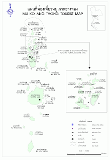
Visitors can hire a boat on Ko Samui to Ang Thong. The charge depends on the boat size and number of passengers. The trip takes 1.30 hours. It is also possible to join a full-day excursion organized by tour operators in Ko Samui.

3. Ko Tao

Boat services for Ko Tao are available at Na Thon Pier of Ko Samui.

Map:Suratthani

SURATTHANI : Map
[ Click to map ]
[ Click to map ]
[ Click to map ]
[ Click to map ]


How to get there:suratthani


By Car

Surat Thani can be most conveniently reached by car from Bangkok by taking Highway No. 4 to Chumphon Province via Phetchaburi and Prachuap Khiri Khan Provinces and then taking Highway No. 41 and Highway No. 401 directly to Surat Thani City.


By Bus

Air-conditioned buses depart from Bangkok's Southern Bus Terminal to Surat Thani Province everyday. Call the southern Bus Terminal tel: 0 2434 5557-8 or visit http://www.transport.co.th/


By Train

Trains leave Bangkok's Hua Lamphong Railway Station 10 times daily from 12 p.m. until 10.50 p.m. The trip takes approximately 12-13 hours. Ask for the train from Bangkok to Phun Phin, the closest station to Surat Thani. For further details, please call 1690, 0 2223 7010, 0 2223 7020 or visit http://www.railway.co.th/Surat Thani Railway Station is 12 kilometers from town. A bus service between the station and the town is available.


By Air

Thai Airways International has 2 daily flights connecting Bangkok with Surat Thani. The flight time is approximately 70 minutes. For more information, contact their Bangkok office at tel. 1566, 0 2280 0060, 0 2628 2000 or get your on-line e-ticket at http://www.thaiairways.com/

One-two-Go also operates flights to Surat Thani. For more information please visit http://www.fly12go.com/ or contact call center 1126.

Air Asia offer flights Bangkok-Surat Thani. For more information please visit http://www.airasia.com/ or call 0 2515 9999


By Boat

Seatran (077 275060, 136 Na Meuang Road) operates a bus/boat combination to Ko Samui. The fee is 150 baht.

Phantip Travel (077 272230, 293/6-8 Talat Mai Road) offers tickets to Ko Tao (500 baht), Ko Pha-Nhan (250 baht), and Ko Samui (140 baht). The operator is Raja Ferry (07 314523, 077 371151 or 077 371206) who offers bus/boat combinations to the islands.

Getting around the cityApart from the local orange bus (9 baht / trip / person),songthaews are another option to get around the city. It costs 10 baht / trip / person. Samlors will cost approximately 20-30 baht. The orange bus departs from the Phu Phin train station to the city every 10 minutes from 6.00 a.m. until 8.00 p.m. The same ride by taxi will cost approximately 100 baht.

Air-conditioned vans connecting the airport and town costs 70-80 baht / person / trip. Tickets can be purchased at travel agencies or THAI office (077 272610).

General Information:suratthani


The largest province of the South located 685 kilometers from Bangkok is Surat Thani the province with a name that literally means "City of the Good People". A former capital of the Srivijaya Empire, the province covers an area of approximately 12,891 square kilometers. Surat Thani Province borders the Gulf of Thailand to the north and east, Chumphon Province to the north, Nakhon Si Thammarat and Krabi Provinces to the south, Phang-Nga and Ranong Provinces to the west and Nakhon Si Thammarat Province to the east.


High plateaus and forested mountains are located to the west of the province, while there are low basins in the center and along the eastern coast. This topography has created 14 river basins including Tapee, Pum Duang, Tha Thong, Tha Krajai, Chaiya, Tha Chang which are the most important basins. All rivers in Surat Thani flow east of the province to the Gulf of Thailand.


The numerous islands along the coast makes Surat Thani (often known as Surat in short) a perfect hideaway for vacationers from around the world. The ideal destination for many is the Penang-sized Ko Samui, Thailand’s third largest island, and its neighbour Ko Pha-ngan a celebrated island that hosts the biggest beach full moon party. North of Ko Pha-ngan is Ko Tao, renowned for its excellent coral reefs. To top it all is the dazzling 250-square-kilometer Ang Thong Marine National Park, where a stunning archipelago awaits to greet visitors with their charming palm-fringed beaches, crystal clear water and colorful coral reefs. The best time to enjoy one of these islands to the fullest is from April to November.

History of Surat Thani

Surat Thani is a city with a long history. Archeologists believe that it was once a community of prehistoric tribes of indigenous people including the Saemang and original Malays who built their communities on the Tapee River Basin and Ao Ban Don. Later on, the Indians migrated into the area and gradually spread out their culture, as evidenced in the discovery of ruins of ancient communities in Tha Chana and Chaiya Sub-districts.


In the 13th century, the city became a part of and, as some historians might claim, a center of the glorious Srivijaya Empire the kingdom that dominated the whole Malay Peninsula and much of Java. It was during this period that Mahayana Buddhist reached its height of influence. The empires grandeur can still be admired in many areas of Chaiya District.

When the empire hit the bottom, it was divided into 3 main cities namely Chaiya, Tha Thong and Khiri Rat. They were all under the jurisdiction of Nakhon Si Thammarat until King Rama IV decided to move Tha Thong City to Ban Don and required that it report directly to Bangkoks administration. The name Ban Don was, at the time, changed to Kanchanadit. It was with the establishment of the Monthon, a former administrative unit, that all three cities were merged into one under the name Chaiya. In 1915, King Rama VI changed the name Chaiya to Surat Thani.

The seal of Surat Thani says a lot about its history. Featuring the pagoda of Phra Boromathat Chaiya, the seal is proof of the influence of Mahayana Buddhist on Surat Thani. Phra Boromathat Chaiya is the most revered and important historical place in the province. It is believed that the pagoda contains Buddha relics.

Today, Surat Thani is an important commercial and shipping hub for rubber and coconut trading.

Attraction

Doi Inthanon National Park

This national park which covers an area of 1,005 square kilometers is located on Doi Inthanon, Thailand’s highest mountain which is 2,565 meters above sea level. Located between Mae Chaem and Chom Thong, the park is comprised of the largest tract of upper mountain forest which ranges across Nepal, Bhutan, Myanmar, and ends in Northern Thailand. The mountain ranges gave birth to the main tributaries of the Ping river and formed the beautiful waterfalls, namely Siriphum, Wachirathan, Mae Pan, Mae Klang and Mae Ya. The moist and dense evergreen forest is abundant with lichens and wild orchids. The park is also a paradise for bird lovers.

Visiting Doi Inthanon is possible throughout the year however, the best period for viewing the waterfalls is May through November while the best period for viewing wild flowers is December through February and for ornithologists is November through March.


Getting there: Travel 58 kilometres west of Chiang Mai via Highway No. 108 to Chom Thong, then turn right into Highway No. 1009 and continue a further distance of 48 kilometres along Highway No. 1009 to the summit. A good asphalt road takes visitors up but is rather steep, thus the vehicle must be in a good condition. Visitors could pay for the entrance fee at Km. 8.

Doi Inthanon can be reached by a local truck (Song Thaeo) from Phra That Chom Thong or Mae Klang Waterfall. The Song Thaeo runs to Doi Inthanon National Park Office (Km. 31) and neighbouring villages. A chartered Song Thaeo costing around 800 baht can make stops at other attractions around the area.

Admission : adult 400 baht, child 200 baht

Facilities :Accommodation, restaurants, and camping sites are available at the park headquarters at Km. 31. Tel: 0 5335 5728, 0 5326 8550, 0 5326 8550, 0 5326 8577 Bangkok Tel: 0 2562 0760 or http://www.dnp.go.th/

Attractions in Doi Inthanon National Park


Namtok Mae Ya is one of the most beautiful cascades in Chiang Mai. Water flows from a 280-metre steep cliff onto different rock formations in a lower basin like drapes. The well-managed waterfall is teeming with verdant forests and is best for recreation. It is located 1 kilometre from Highway No. 1009 junction, turn left for 14 kilometres and then take a 200-metre walk.

Namtok Mae Klang is a 100-metre one-level waterfall located 8 kilometres from Highway No. 1009 junction and turn left onto an asphalt road for 500 metres.

Tham Bori Chinda is a large cave located near Namtok Mae Klang at Km. 8.5 of Highway No. 1009. The road sign to Tham Bori Chinda will be seen at the junction on the right. The deep cave has stalactite and stalagmite formations, Buddha images and a rocky stream. The surface of the water glitters like diamonds flake when light reflects the stream. Sunlight in the cave allows visitors to see the entire cave.

The Tourist Centre at Km. 9 has exhibits on nature and animals that inhabit the area.

Namtok Wachirathan is a large waterfall which plummets over the edge of a high cliff into a deep pool below. When there is a large amount of water, there are large splashes in the basin, creating a cool and refreshing environment. The delightful ambience can be felt by walking on a slippery bridge that leads to the waterfall. To get there, turn right off Highway No.1009 at Km. 21, then follow the signpost to the waterfall a further 350 metres on foot. At Km.20 a new road is built to reduce the walk to the waterfall.

Namtok Siriphum is a splendid waterfall that falls from a steep cliff in two lines and can be seen en route to Doi Inthanon. The attractive waterfall is located at Km. 31 of Highway No. 1009, take a right turn for 2 kilometres and is approachable only on foot from the base of the waterfall.

Doi Inthanon Royal Project is in Khun Klang village close to the park headquarters. The project was initiated in 1979 to help the hill tribes to cultivate cash crops other than opium and train them on modern agricultural practices. Most produces are temperate zone plants. Flower plantations, a plant breeding research lab and flower plantations of hill tribes (Hmong) are open to visitors.


Phumisiri, twin pagodas located at Km. 41.5, were built to commemorate the fifth cycle birthdays of King Bhumibol Adulyadej and Queen Sirikit. Both pagodas share the similar bases as well as a two-level walking path that surrounds them. The pagodas enshrine Lord Buddha’s ashes and Buddha images, and overlook the magnificent scenery of Doi Inthanon.

Doi Inthanon Peak has a cool climate all year round. The Air Force Radar Station and King Inthawichayanon’s stupa located on the mountaintop. King Inthawichayanon, the last king of Chiang Mai, was concerned about the importance of forests and wanted to preserve the forests for future generations. He was so familia with Doi Inthanon that he asked that part of his ashes be kept here. The Tourist Information Centre, near the top of Doi Inthanon, exhibits a chronological background of the mountain, including its geography, biology, forests, and animals.

Namtok Mae Pan is the longest waterfall in Chiang Mai, which flows from a 100-metre cliff. Its charm can be enjoyed by standing some distance from the falls. From afar, the white water and the green forests around the falls make a beautiful picture. From Km. 38 of Highway No. 1009, drive along the Doi Inthanon-Mae Chaem road (Highway No. 1192) for 6 kilometres and a sign to the waterfall will be seen, then drive on an unpaved road for 9 kilometres. The lovely waterfall can be reached by a ten-minute walk from a parking lot. In the rainy season, the road to Namtok Mae Phan is in a poor condition; only a four-wheel vehicle could make the journey.

Namtok Huai Sai Lueang is beyond Namtok Mae Pan, about 21 kilometres from Doi Inthanon-Mae Chaem Road. Turn left to an unpaved road where only a four-wheel vehicle could make a trip in the rainy season. The medium-size cascade has water all year round and flows from a cliff to each level.

Natural Study trek on Doi Inthanon Kiu Mae Pan starts from Km. 42. This short trail, winding through pristine forest for about 2.5 kilometres, a 3-hour walk, allows the hiker to experience the natural beauty of the forest at first hand. The Rhododendrons, commonly found in the Himalayas, are found along the trail and they are in full bloom during December-February. Trekkers on this route should seek permission from the park headquarters at Km. 31 for safety reasons. A group of not more than 15 people is recommended. Food consumption is not allowed while trekking. This nature trail is closed for reforestation from June 1 to October 30 annually.


Ang Ka Luang Nature Trail was surveyed and designed by Mr. Michael MacMillan Walls, a Canadian volunteer biologist who devoted to his work and died from a heart attack on this mountain. This trail is 360 metres long, passing through wet and cold areas in a lush valley. Forest above 2,000 metres is covered with lichens and wild orchids. Indigenous plants that needs a high level of nutrition, organic deposits, and rare species of birds are seen along the trail.

There are more nature trails on Doi Inthanon, each providing different views of the diversity of plants, reforestation, the importance of tributaries, the origin of caves, hilltribe agriculture, and birdwatching. Walking trails range from 1 to 8 kilometres. Each trip needs approval from the Chief of the National Park and a trekking leader is needed. The service is obtained at the Park Office at Km. 31.

Birdwatching on Doi Inthanon Inthanon

Birdwatching Information Centre (Uncle Daeng’s Shop) is located at Km. 31. This is a bird information exchange centre among birdwatchers, nature students and the general public. The information details the habitat and food of birds and animals living on Doi Inthanon. The aim is to pass on this knowledge to the next generation. It also provides the Doi Inthanon Birdwatching Diary, bird sketches by various bird watching experts, birdwatching trails, bird pictures, and slides.
Winter is the best time for birdwatching when indigenous and migrant birds are found including Eurasian Woodcock, White Wagtail, Grey Wagtail, Yellow Wagtail, Citrine Wagtail, Forest Wagtail, Chestnut Thrush, Scarlet Finch, Little Bunting, and Crested Bunting.
Phra Mahathat Napha Methanidon and Phra Mahathat Naphaphon

map

CHIANG MAI TOURIST MAP


CHIANG MAI CITY MAP

[ Click to enlarge map ]

General Information


Experiencing the merging of the past into the present in Chiang Mai where locals are proud of the city’s 700-year history. Its rich traditional heritage and unique culture is a perfect foundation for the development of the city. Chiang Mai is one of the few places in Thailand where it is possible to find in the heart of the city centuries-old chedis and temples next to modern convenience stores and boutique hotels. The original city layout still exists as a neat square surrounded by a moat with vestiges of the fortified wall and its four main gates offering prime access to the old town.

For years, tourists have mistaken Chiang Mai as the northern junction and the base from which they can explore other provinces. The phrase "a day in Chiang Mai is enough to see things around" was common. Today, tourists are surprised by the fact that there is always something new to discover Chiang Mai. Intriguing diversity among ethnic tribes coupled with breathtaking scenery makes Chiang Mai one of Asia’s most attractive tourist destinations. Two weeks in Chiang Mai may not be long enough for serious travelers.
The old city of Chiang Mai with its fascinating indigenous cultural identity such as diverse dialects, cuisine, architecture, traditional values, festivals, handicrafts and classical dances is a prime location in its own right. In addition, the presence of hill tribes and their wealth of unique cultures enhance Chiang Mai’s distinctive diversity.


Chiang Mai is also blessed with pristine natural resources of mountains (dois), waterfalls, and other nature-based tourist attractions. At the same time, Chiang Mai residents are warm, gracious and congenial providing authentic hospitality making visits memorable and meaningful. Moreover, visitors from all walks of life can collect handicrafts of silk, silver and wood produced locally as timeless souvenirs. Chiang Mai is a place where both backpackers and luxury tourists can enjoy themselves to the fullest.

The Past

Chiang Mai literally means new city and has retained the name despite having celebrated its 700th anniversary in 1996. King Meng Rai founded the city as the capital of the Lanna (A Million Rice Fields) Kingdom on Thursday, 12th April 1296 during the same period of time as the establishment of the Sukhothai Kingdom. King Meng Rai the Great conferred with his friends, King Ramkhamhaeng of Sukhothai and King Ngam Muang of Phayao before choosing the site where the capital of the Lanna Kingdom was to be founded.

From then, Chiang Mai not only became the capital and cultural core of the Lanna Kingdom, it was also the centre of Buddhism in northern Thailand. King Meng Rai himself was very religious and founded many of the city’s temples, which are still important today.
At the height of its power, the Lanna Kingdom extended its territory far into Burma and Laos, and southwards to Kamphaeng Phet a province above Sukhothai.

The Burmese conquered the Lanna Kingdom in 1556 ending the dynasty founded by King Meng Rai that lasted over 250 years. As Burma had occupied Chiang Mai for nearly 200 years, Burmese architectural influences are visible in many temples. At the end of the 18th century, King Taksin the Great regrouped the Thais in the south and finally drove the Burmese out with the help of King Kawila of Lampang thereby regaining Thai independence from Burma. Chiang Mai was then governed by a succession of princes who ruled the north as a Siamese protectorate under the Chakri dynasty. In the late 19th century, King Rama V appointed a high commissioner in Chiang Mai and it was only in 1939 that Chiang Mai finally came under the direct control of the central government in Bangkok the same time the country was renamed Thailand.

In the past, Chiang Mai was only accessible by river and elephants. More convenient access was achieved only when the railway line was completed in the late 1920’s. Moreover, the first motor vehicle driven directly from Bangkok arrived in Chiang Mai in 1932. Such isolation was more favorable to Chiang Mai as it helped to nurture and preserve the unique Lanna culture.

When we look at Chiang Mai today, it is the economic, cultural and communications hub of northern Thailand complete with excellent infrastructure, good roads, by passes and road tunnels, and reliable communications infrastructure.

The Setting

Chiang Mai, with an altitude of approximately 310 meters above sea level, is situated approximately 700 kilometers from Bangkok on the Mae Ping River basin. Surrounded by high mountain ranges, the city covers an area of approximately 20,107 square kilometers and is the country’s second largest province. Chiang Mai borders Myanmar on the north, Lamphun and Tak Provinces on the south, Chiang Rai, Lampang and Lamphun Provinces on the east and Mae Hong Son Province on the west. The terrain is mainly comprised of jungles and mountains, which are home to the hill tribes. In addition, wildlife and exotic flora may be found in the national parks.

Most of Chiang Mai’s mountains are oriented from north to south. Together they create a multitude of streams and tributaries including Mae Chaem, Mae Ngat and Mae Klang. One of Chiang Mai’s distinctive features is Doi Inthanon, Thailands highest peak, which is 2,575 meters above sea level. In addition, the province boasts flat, fertile valleys, which spread along the banks of the largest and most important river in Chiang Mai Mae Nam Ping (Ping River) which originates from the Chiang Dao mountain range.

Attraction


Doi Pha TangDoi

Pha Tang, about 160 kilometres from the provincial town, is a viewing point on top of a high cliff over the Thai-Laotian border affording a delightful scene for the river and the sea of mist throughout the year. During December-January, blooming Sakuras provide a picturesque scenery. It is home to the Chinese Haw, the Hmong and Yao minorities. The Haws are the remnants of the 93rd Chinese Division who moved in to settle on Doi Pha Tang. There are a lots of bungalows & tents serve tourists


Wat Phra That Doi Chom Thong

It is located on Doi Chom Thong on the bank of the Kok River within town area, contains what is believed to be the oldest Holy Relic even before King Mengrai built Chiang Rai. The Chedi containing the Holy Relic was probably renovated at the same time the town was being built. A major religious site in Chiang Rai was from here that King Mengrai spotted the strategic location on which to establish the town. Tel: 0 5371 6055


Wat Phra Sing

Wat Phra Sing is located near the townhall used to house a major Buddha statue, the Phra Buddha Sihing which is now enshrined in Chiang Mai. A special feature is the Lanna-style Ubosot and the wooden door panels carved by Chiang Rai contemporary craftsmen. Tel: 0 5374 5038


The King Mengrai the Great Memorial

It is located in the town on the intersection leading to Mae Chan. Originally, King Mengrai was the ruler of Nakhon Hiran Ngoen Yang (an ancient town on the bank of the Mae Khong around Chiang Saen) before Chiang Rai was established as the administrative centre in 1262. He consolidated his power by merging the different city in the North and founded the Lanna Thai Kingdom in 1296 with Chiang Mai as the capital


Khun Chae National Park

Khun Chae National Park is located at Tambon Mae Chedi Mai of Wiang Pa Pao District. It can be reached by taking the Chiang Mai - Chiang Rai Route (Highway No. 118). The park headquarters is right next to the highway at kilometers 55-56. Visitors wishing to take a jungle trek and camp within the park need to procure the services of a guide and prepare their own camping equipment. The trek through the Khun Chae jungle is for adventure travel enthusiasts as the route passes through steep terrain and several hilltops and cliffs over 1,400 meters high. There are good scenic lookout points and trekkers can enjoy waterfalls, flowing streams and virgin jungle areas covered with various plants.


Phu Chi Fa

Phu Chi Fa is approximately 25 kilometers to the south of Doi Pha Tang in Thoeng District. The cool climate produces colorful flowering shrubs and the large meadow on the top provides breathtaking views of Laos. In addition, spectacular scenery can be seen from the sheer cliff of Phu Chi Fa, especially the sea of mist at sunrise. Visitors can stay overnight at Ban Rom Fa Thong and Ban Rom Fa Thai


Doi Luang National Park

Doi Luang National Park is 65 kilometers south of Chiang Rai town and covers an area of 1,170 square kilometers in Phan District. Apart from hiking trails, the forested park features a few waterfalls of which the largest is Pu Kaeng Waterfall. This impressive fall has nine leaps and flows all year round. To reach Pu Kaeng Waterfall drive along the Chiang Rai-Phayao route for 58 kilometers to arrive at Ban Pu Kaeng. At kilometer 77, take a right turn and proceed on for another 9 kilometers. It is a large waterfall amid virgin jungle with water cascading down limestone brooks. Camping areas and jungle trekking services are available

The construction started in 1998 and is expected to be completed in 2008. In addition, there is a gallery nearby exhibiting his paintings. To get there from the city of Chiang Rai, drive north along Asia Highway.


Wat Rong Khun

Wat Rong Khun is also known as the White Temple. Whereas most temples visited by tourists have a history going back many centuries, this magnificent place of worship was built only recently. It is the realization of a dream for Thailands noted artist, Mr Chalermchai Kositpipat, who designed and is supervising the construction of this beautiful white temple and its many statues of figures based on religious beliefs. The construction started in 1998 and is expected to be completed in 2008. In addition, there is a gallery nearby exhibiting his paintings. To get there from the city of Chiang Rai, drive north along Asia Highway.

map

CHIANG RAI TOURIST MAP
--
Chiang Rai City Map

[ Click to enlarge map ]

General Information

CHIANG RAI
Chiang Rai, the northernmost province of Thailand is about 785 kilometers north of Bangkok. Situated on the Kok River basin, Chiang Rai covers an area of approximately 11,678 square meters with an average elevation of 580 meters above sea level. The province, which is located within the renowned Golden Triangle area where Myanmar, Laos and Thailand converge, is also known as the gateway to Myanmar, Laos and Southern China.


Chiang Rai, which was founded in 1262 by King Meng Rai,was the first capital of the Lanna Thai Kingdom (Kingdom of a million rice fields), which was later conquered by Burma. It was not until 1786 that Chiang Rai became a Thai territory and was proclaimed a province during the reign of King Rama VI in 1910.
Today, Chiang Rai is a travelers paradise endowed with abundant natural tourist attractions and antiquities; the province itself is evidence of past civilization. Attractions range from magnificent mountain scenery, ruins of ancient settlements, historic sites, Buddhist shrines and ethnic villages as the province is also home to several hill tribes who maintain fascinating lifestyles. For those interested in the natural side of Chiang Rai, jungle trekking is recommended along various trails.
Chiang Rai which tends to be a little more ’laid back’ now competes with Chiang Mai as a tourist attraction and is fast becoming a popular escape for tourists wanting to get away from the troubles they left behind.

Attraction

***
The Kamphang Phet National Museum

The Kamphang Phet National Museum, located on Pindamri Road in Muang district, houses ancient objects and other antique arts articles from various eras found in the provincial town. These include sculptured and earthen designs, heads of Buddha statues, traditional celadon products, sculptures of demons and celestial and human beings used to decorate Chedi bases or Vihans. It is open Wednesday-Sunday from 9.00 a.m.-4.00 p.m. More information at Tel: 0 5571 1570.


Kamphang Phet Historical Park

Major features of Kamphang Phet Historical Park include archaeological remains of ancient sites such as Muang Chakangrao to the east of the Ping River, Muang Nakhon Chum to the west and Muang Trai Trueng some 18 kilometres from the town to the southwest. Services from the Tourist Centre are available, the centre itself being located some 5 kilometres from town on the Kamphaeng Phet-Phran Kratai route.


Chakangrao, the ancient Kamphaeng Phet town, had the same town planning concept as the old Sukhothai and Si Satchanalai, with separate zones for religious sites both within and outside of town limits. Structures are usually large and made of laterite. Religious sites on the west bank of the Ping River at Nakhon Chum are built of bricks and of smaller size.

Remains of the ancient sites within the city walls are as follows:

City Walls and Old Fortifications mark the boundary of the rectangular town area, measuring 300-700 metres wide and 2,200 metres long.

Phra Kaeo Temple (Wat Phra Kaeo) is a large royal temple in town centre near a site believed to have been a palace. The temple itself was used on important city events and had no monks in residence. Major features include the principal chedi with lion-adorned base and a round chedi with elephant-adorned base. There are also other chedis of different bases and remains of several chapels. Its boundary is marked off by laterite walls.

Second in size to Wat Phra Kaeo is Phra That Temple. Here the principal chedi is built of mixture of laterite and bricks with a 15-metre wide square base. The style is of Kamphaeng Phet architecture.

Sa Mon is the site of the palace located to the north of Wat Phra Kaeo with a square earthen wall almost touching the northern city wall. Surrounded the walls on three sides are moats with a pond in the middle. There are no standing structures remaining today.

Phra Non Temple (Wat Phra Non) is fenced in by laterite walls on four sides. At the front of the temple are a square-shaped pond, bathrooms and an ancient floating pavilion which is supported by a large laterite column. The entire column was cut out in one single piece from its source and measures 1.1 meters on each side and 6.4 meters in height, the largest such stone in the country. A lion sculpture and Sema stones (boundary stones) can still be discerned. The large Vihan which once housed the Reclining Buddha has crumbled entirely.

Phra Si Iriyabot Temple (Wat Phra Si Iriyabot) is located to the north of Wat Phra Non and has similar pond and bathroom facilities as its neighbour. Walls on the four sides are of laterite materials with an entrance also made of laterite. A Mondop structure houses Buddha statues in four postures-walking, sitting, standing and reclining in the Sukhothai artistic style. Today only the statue in the standing posture still remains.

Phra Sing Temple (Wat Phra Sing) is believed to have been constructed during both the Sukhothai and Ayutthaya periods. With laterite walls, it has a square-shaped principal Chedi with arches on four sides. In front of the Ubosot are ornamental lion and Naga figurines.

Chang Rop Temple (Wat Chang Rop) is a large temple situated on a high hill. Its main Chedi of Ceylonese style is in the middle of the yard but its top part is broken down. The base is adorned with 68 half-elephants between which are Bhoti-shaped designs. There are also traces of demon and female dancers' figures remaining. Apart from these temples, there are also several ancient sites on the east bank of the Ping River, including Wat Arwat Yai, Wat Kalothai and Phra Ruang Road.

Muang Nakhon Chum is an ancient town on the west bank of the Ping River. Its 2-3 metre-high earthen walls run along the waterway. It is in this area that the famous religious tablets of Kamphaeng Phet have been discovered. Within the city walls are a couple of ancient sites such as the Kamphaeng Pom Thung Sethi located on Phahonyothin Road just before entering the town. It is part of the laterite fortifications 83 metres long and 6 metres tall.

Phra Borom Temple (Wat Phra Borom) That is a temple situated in the centre of Muang Nakhon Chum featuring a Burmese-style Chedi. To the south is an Ubosot housing several Sukhothai- and Ayutthaya-style bronze Buddha statues. The Chedi itself is believed to originally have been a Sukhothai-type structure, its style having been altered during a restoration work financed by a wealthy Burmese about a century ago.

Another ancient town is Muang Trai Trueng. It was built by King Chaisiri of Chiang Rai who fled invading enemy in 1542 B.E. (circa 999). Today most of the structures are in disrepair with only ruins of Chedis and ramparts. The town is about 18 kilometres from Kamphaeng Phet on the Kamphaeng Phet-Khlong Lan road.


Mae Wong National Park

The Mae Wong National Park forms the border between Kamphaeng Phet and Nakhon Sawan and covers an area of about 894 square kilometres. Most of the land is rich in various types of plants. Along the Khlong Lan -Umphang route passing through the park's area, which leads up to the mountains, are several viewing points between Kms. 81 to 115. At Km. 102 is a beautiful road-side waterfall. Other falls within the park include the Mae Krasa, Mae Liwa and others. To visit these attractions tourists need to go on foot and overnight in the jungle.


Khlong Lan National Park


Khlong Lan National Park covers an area of some 300 square kilometres over mountain ranges to the west of the province. The highest peak is about 1,400 metres. Of mainly virgin jungles, it is the source of several streams which flow into the Ping River.
The park headquarters is near the Khlong Lan waterfall about 60 kilometres from town on the route to Khlong Lan district (highway no.1117). Attractions within the park include the 95-metre high Khlong Lan Fall with scenic surroundings, and the Khlong Nam Lai Fall, a 9-level cascade and located off Highway no.1117 at Km. 35 and 10 kilometres further on). The Kaeng Ko Roi (off Highway No.1117 at Pong Nam Ron intersection) is a group of rock formations jutting out of the stream looking somewhat like all islands. Visitors can camp overnight within the park.


The Kamphang Phet Province Museum

The Kamphang Phet Province Museum nearby is made up of groups of Central Region applied architectural style structures. There are exhibitions on the local history with replicas of the city, lifestyle and urban and hill tribal customs and traditions. It also displays the development of Kamphaeng Phet votive tablets and other resources. The museum is open daily. For more information, call 0 5572 2341.


Banana Market (Talat Kluai Khai)

This market is on the Kamphaeng Phet-Nakhon Sawan highway at Km.343. Scores of roadside stalls display and sell both raw and ripe Kluai Khai (a type of bananas).


Khao Sanam Priang Wildlife Sanctuary

Located in Tambon Kosampi, Lan Dok Mai Tok of Kosampi Nakhon sub-district and Tambon Na Bor Kham, Song Tham, Nakhonchum or Amphoe Mueang. Linked with Kanna and Kew Yao mountains, Khao Sanam Priang Wildlife Sanctuary enjoys not only fertile pinery, fern forests, but also a large variety of wildlife. With 1.5 km. trekking route, it is worth visiting. For camping tour, a written note must be sent to the department of forestry in advance. No accommodation, but camping site is available, contact tel. 0 5555 6157 or 0 2562 0760.

To get there, take Asia Highway Route no 1 and turn left of km 380. By bus from town center visitors have to hire a songtaew to the sanctuary.

Map


KAMPHAENGPHET TOURIST MAP

[ Click to enlarge map ]

KAMPHAENGPHET CITY MAP

How to get there


By Car
From Bangkok, take Highway No. 32 to Nakhon Sawan via Ayutthaya, Ang Thong and Sing Buri and then proceed along Highway No. 1 to Kamphaeng Phet, a total distance of 358 kilometres.


By Bus
Both air-conditioned and non air-conditioned buses leave Bangkok's Mochit 2 Bus Terminal every day. Call 0 2936 2852-66 or visit http://www.transport.co.th/ for more information.


Distances from Amphoe Mueang to Other Districts

General Information

**
General Information

Geographically located in the Lower North on the bank of the Ping River, Kamphaeng Phet is 358 kilometres from Bangkok. To its East are riverine flatlands while the western areas are made up of high mountains lush with fertile forests where a number of national parks have been established. Areas along the river bank at present-day Mueang district used to host several ancient towns which had played a major role as strategic front-line frontiers since Sukhothai was the kingdom's capital down through the times of Ayutthaya and early Rattanakosin (Bangkok) eras. In fact, the name Kamphaeng Phet actually means as strong as walls or forts make of diamonds.
Kamphaeng Phet covers an area of 8,607 square kilometres. It is divided administratively into 9 districts, namely, Mueang Kampheang Phet, Phran Kratai, Khlong Khlung, Khanu Woralaksauri, Sai Ngam, Lan Krabue, Khlong Lan, Sai Thong Watthana and Pang Sila Thong and 2 sub-districts, Bueng Samakkhi and Kosamphi Nakhon.
Powered by  MyPagerank.Net Msn bot last visit powered by MyPagerank.Net Yahoo bot last visit powered by MyPagerank.Net